aquifers
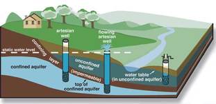
Aquifers can be defined as a rock layer that is permeable to the flow of groundwater in amounts that are usable to population.
These are formed as water from the surface which permeates down through the rock and soil. It is absorbed into the porous rocks between the rock granules. The more that the soil is permeable, the more water it is able to absorb over time. As the water builds up and gathers in the spaces between the rocks, it builds up a layer of groundwater below the surface and fills the water table (the upper limit of the collected water).
These are formed as water from the surface which permeates down through the rock and soil. It is absorbed into the porous rocks between the rock granules. The more that the soil is permeable, the more water it is able to absorb over time. As the water builds up and gathers in the spaces between the rocks, it builds up a layer of groundwater below the surface and fills the water table (the upper limit of the collected water).
ogallala aquifer
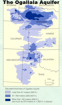
The Ogallala Aquifer is a vast shallow underground water table aquifer beneath the Great Plains in the United States. Its one of the largest aquifers covering approximately 174,000mi2 and covers eight states including South Dakota, Kansas and Oklahoma. About 27% of the irrigated land in the US overlies this aquifer system and yields about 30% of all the ground water used for irrigation in the US.
The deposition of the material within the aquifer dates back to 2 - 6 million years. From the uplands to the west, rivers and streams cut channels in a generally west to east or southeast direction. The depth of the aquifer varies in shape, its at its deepest where it fills ancient valleys and channels. The Ogallala mainly consists of coarse sedimentary rocks at its deepest sections.
Threats
Users
Managers
The deposition of the material within the aquifer dates back to 2 - 6 million years. From the uplands to the west, rivers and streams cut channels in a generally west to east or southeast direction. The depth of the aquifer varies in shape, its at its deepest where it fills ancient valleys and channels. The Ogallala mainly consists of coarse sedimentary rocks at its deepest sections.
Threats
- Pipeline has been proposed to build over it - The Keystone XL pipeline has the potential to threaten the aquifer in much of central U.S. TransCanada, a water key player is the organisation who said that they will be installing the pipeline at least four feet underground could be putting many places at risk of water depletion. The installation of the pipeline will disrupt the aquifer and if it was to spring it leek when it touchers the aquifer, oil could quicker seep into and through the porous sandy soil.
- Depletion - Use of the Ogallala began at the turn of the century; since World War II reliance has been steadily increased. The withdrawal of this groundwater has surpassed the aquifers rate of natural recharge. Some places overlying have already exhausted their underground supply as a water source of irrigation. However, some other parts of the aquifer have better recharge rates so are less vulnerable.
- Pollution -
Users
Managers
- Water companies - these companies have lots of power and influence over the usage, management, structure and future of the aquifer. They determine and dramatically influence how the users of the aquifer benefit from the resource or not.
- Government (both state and federal) - governments have the most power over what happens at this aquifer as well its future. The decisions that the government makes affects the consumers, agriculture industry, water companies as well as more local government. They can be considered to have the most influence.
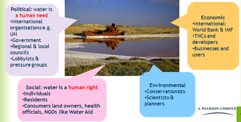
This picture diagram from Edexcel helps us to understand the key players in the decisions people have to make for water sources like the Ogallala Aquifier.
Click on this image to read an article on the Texas Water District acting upon the depletion of the Ogallala Aquifer.
